
How the DJI Matrice 4 Transforms Aerial Mapping
In the fast-paced world of construction and environmental management, staying ahead of the curve is key, and the DJI Matrice 4 is proving to be a game-changer in this regard. This cutting-edge drone, equipped with RTK technology, is making waves by dramatically enhancing the precision of aerial surveys and topographical mapping. Its advanced features, such as smart capture, allow for the creation of ultra-realistic 3D models and highly detailed orthomosaic maps. Join us as we explore how this remarkable tool is transforming aerial mapping and data collection, offering construction site managers and environmental officers a reliable ally in their projects. With firsthand accounts from industry professionals, we’ll explore how the DJI Matrice 4 is setting new standards in aerial imaging.
Aerial Mapping
Aerial surveys have come a long way, and the DJI Matrice 4 is at the forefront of this evolution. Let’s explore how this advanced drone is changing the game for construction and environmental professionals.
The Power of the DJI Matrice 4
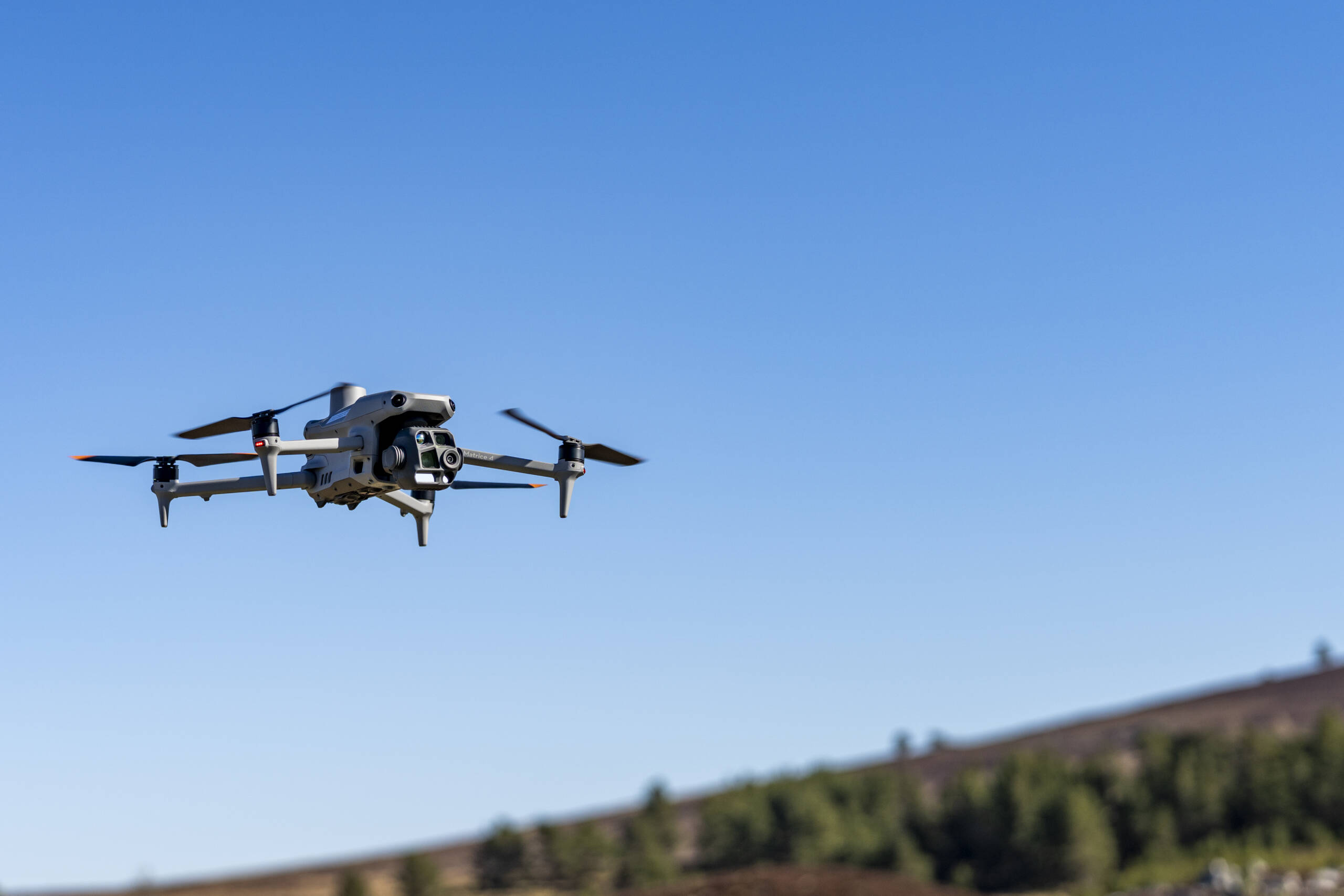
The DJI Matrice 4 is a powerhouse in the world of aerial mapping and surveys. Its robust design and cutting-edge technology make it an ideal choice for professionals seeking precision and reliability.
This drone boasts an impressive array of features, including a high-resolution camera, extended flight time, and advanced stabilisation systems. These elements work together to provide unparalleled aerial imaging capabilities.
The Matrice 4’s ability to operate in challenging environments sets it apart. Whether facing windy conditions or complex terrains, this drone maintains stability and delivers consistent results
With its user-friendly interface, even those new to drone technology can quickly master its operation. This accessibility, combined with its professional-grade output, makes the Matrice 4 a valuable asset for any survey team.
Survey grade accuracy
Accuracy is paramount in aerial surveys, and the DJI Matrice 4 excels in this area. Its Real-Time Kinematic (RTK) technology significantly improves the precision of data collection.
RTK allows the drone to receive real-time corrections to its GPS positioning. This results in centimetre-level accuracy, a vast improvement over traditional GPS systems.
The Matrice 4’s high-resolution camera captures detailed images that can be stitched together to create accurate maps and models. This level of detail is crucial for projects requiring precise measurements and analysis.
The drone’s ability to maintain a stable flight path ensures consistent data collection across large areas. This consistency is vital for creating reliable survey results that professionals can confidently use in their decision-making.
Transforming Aerial Mapping
The DJI Matrice 4 is revolutionising the field of aerial mapping, offering unprecedented levels of detail and accuracy. This section delves into the specifics of how this advanced drone is changing the landscape of topographical mapping and its implications for construction projects.
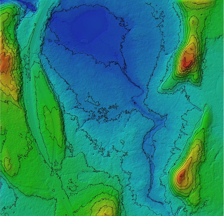
Orthomosaic Maps Explained
Orthomosaic maps are a cornerstone of modern aerial mapping, and the DJI Matrice 4 excels in creating these detailed representations. But what exactly are orthomosaic maps?
An orthomosaic map is a detailed, accurate photo representation of an area, created by combining many orthophotos into a single image. This process involves taking multiple overhead images and stitching them together to form a comprehensive view.
The Matrice 4’s high-resolution camera captures these images with exceptional clarity. Its stable flight patterns ensure consistent overlap between photos, which is crucial for creating seamless orthomosaic maps.
The resulting maps are geometrically corrected (‘orthorectified’) to ensure a uniform scale. This correction eliminates distortions caused by camera angles, lens characteristics, and topographical relief.
These maps serve as valuable tools for land surveying, urban planning, and environmental monitoring. They provide a bird’s-eye view of large areas while maintaining the detail necessary for precise measurements and analysis.
Precision in Topographical Mapping
The DJI Matrice 4 brings a new level of precision to topographical mapping. Its advanced sensors and processing capabilities allow for the creation of highly accurate Digital Elevation Models (DEMs).
These DEMs provide a three-dimensional representation of a terrain’s surface. The Matrice 4’s ability to capture data from multiple angles ensures that even complex landscapes are accurately represented.
The drone’s RTK technology plays a crucial role in this precision. By providing real-time corrections to GPS data, it allows for the creation of maps with centimetre-level accuracy.
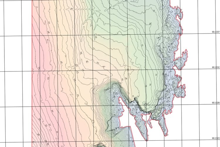
This level of detail is particularly valuable in areas with subtle elevation changes. It allows surveyors to identify features that might be missed by less precise mapping methods.
The Matrice 4’s efficiency in data collection means that large areas can be mapped quickly and accurately. This speed doesn’t come at the cost of quality, making it an invaluable tool for time-sensitive projects.
Benefits for Construction Managers
Construction managers are finding the DJI Matrice 4 to be an invaluable asset in their project planning and execution. The drone’s mapping capabilities offer numerous benefits throughout the construction process.
In the initial planning stages, the detailed orthomosaic maps and DEMs provided by the Matrice 4 allow for more accurate site assessments. This precision helps in identifying potential challenges early in the project lifecycle.
During construction, regular surveys can track progress and detect any deviations from the plan. This real-time monitoring capability enables quick decision-making and problem-solving.
The drone’s ability to safely survey hard-to-reach areas reduces the need for manual inspections, enhancing worker safety. It also allows for comprehensive site documentation without disrupting ongoing work.
Post-construction, the Matrice 4 can be used for final surveys and as-built documentation. The accuracy of these surveys provides valuable data for future maintenance and potential expansions.
Advancements in 3D Modelling
The DJI Matrice 4 is not just about 2D mapping; it’s also pushing the boundaries of 3D modelling. This section explores how the drone’s advanced features are enabling the creation of highly detailed and accurate 3D models.
Smart Capture Capabilities
The DJI Matrice 4’s smart capture capabilities represent a significant leap forward in aerial imaging technology. This feature set allows for intelligent, automated data collection that enhances the quality and efficiency of 3D modelling.
At its core, smart capture involves the drone’s ability to automatically plan and execute complex flight paths. This ensures comprehensive coverage of the target area, capturing images from multiple angles and elevations.
The Matrice 4’s advanced sensors work in tandem with its smart capture system. They continuously monitor the drone’s position and orientation, adjusting the camera settings in real-time for optimal image quality.
This intelligent system also manages data storage efficiently. It can prioritise the most important images, ensuring that critical data is never lost due to storage limitations.
The result is a streamlined workflow that reduces the time and effort required to collect high-quality data for 3D modelling. This efficiency is particularly valuable for large-scale or time-sensitive projects.
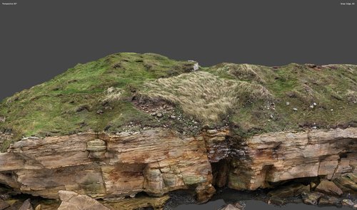
Creating Ultra-Realistic Models
The DJI Matrice 4’s ability to create ultra-realistic 3D models is transforming how professionals visualise and interact with spatial data. These models offer an unprecedented level of detail and accuracy.
The process begins with the drone’s high-resolution camera capturing hundreds or even thousands of images from various angles. These images are then processed using advanced photogrammetry software.
The software analyses the overlapping areas in the images to determine the exact position of each pixel in 3D space. This process, known as structure from motion, results in a dense point cloud.
From this point cloud, a detailed mesh is created, representing the surface of the scanned area. Textures from the original images are then applied to this mesh, resulting in a photorealistic 3D model.
The level of detail in these models is astounding. Features as small as individual bricks on a building or leaves on a tree can be clearly visible, depending on the flight altitude and camera resolution.
Building Trust Through Drone Services
The DJI Matrice 4 is not just a tool for mapping and modelling; it’s also opening up new possibilities in various drone services. This section explores how these services are building trust and delivering value across different industries.
Drone Inspections for Infrastructure
The DJI Matrice 4 is proving to be an invaluable tool for infrastructure inspections. Its ability to access hard-to-reach areas safely and efficiently is changing how we maintain and monitor our built environment.
For bridge inspections, the drone can capture detailed images of structural elements without the need for expensive scaffolding or putting inspectors at risk. This not only saves time and money but also allows for more frequent inspections.
In the energy sector, the Matrice 4 is used to inspect wind turbines and solar panels. Its high-resolution camera can detect minor defects that might be missed by ground-based inspections.
For railway infrastructure, the drone can quickly survey long stretches of track, identifying issues like vegetation encroachment or track deformation. This proactive approach to maintenance can prevent costly disruptions.
In urban environments, the Matrice 4 is used for building facade inspections. It can capture detailed images of high-rise buildings, allowing for thorough assessments without the need for dangerous climbing or expensive lifting equipment.
The Future of Aerial Mapping
As we look to the horizon, the potential applications of the DJI Matrice 4 in aerial mapping continue to expand. This section explores some of the emerging uses and the drone’s role in shaping the future of various industries.
Peatland Restoration Projects
Peatland restoration is an area where the DJI Matrice 4 is making a significant impact. These vital ecosystems play a crucial role in carbon sequestration and biodiversity, and accurate mapping is essential for their conservation.
The drone’s ability to create detailed DEMs is particularly valuable in peatland contexts. It can accurately map the subtle elevation changes that are crucial for understanding water flow and peat formation processes.
Using the Matrice 4, researchers can monitor the progress of restoration efforts over time. Regular surveys can track changes in vegetation cover and water levels, providing valuable data on the success of different restoration techniques.
The drone’s thermal imaging capabilities can be used to detect areas of dry peat, which are at risk of erosion or fire. This information helps in prioritising areas for rewetting and conservation efforts.
By providing a comprehensive view of large peatland areas, the Matrice 4 helps in planning restoration strategies. It allows conservationists to identify key areas for intervention and to monitor the wider impact of their efforts on the landscape.
Environmental Officer Insights
Environmental officers are finding the DJI Matrice 4’s 3D modelling capabilities to be a game-changer in their field. The detailed models provide new perspectives on environmental monitoring and management.
These models allow for precise measurement of vegetation height and density. This data is crucial for assessing habitat quality and monitoring changes over time.
In wetland areas, 3D models can help track water levels and identify potential flood risks. The ability to visualise terrain in three dimensions makes it easier to plan mitigation strategies.
For erosion monitoring, the Matrice 4’s models provide a clear view of landscape changes. This helps in identifying areas at risk and planning appropriate conservation measures.
The models also serve as powerful communication tools. They allow environmental officers to clearly illustrate complex environmental concepts to stakeholders and the public.
Industry-Specific Applications
The versatility of the DJI Matrice 4 is leading to its adoption across a wide range of industries, each finding unique ways to leverage its capabilities.
In agriculture mapping, the drone is being used for precision farming. Its ability to create detailed crop health maps helps farmers optimise irrigation and fertiliser use, leading to increased yields and reduced environmental impact.
For urban planning, the Matrice 4’s 3D modelling capabilities are proving invaluable. Planners can create accurate models of entire cities, helping to visualise the impact of new developments and infrastructure projects.
In peatland restoration projects, the drone’s precise mapping helps researchers track environmental changes and plan targeted conservation interventions to restore these critical ecosystems
Construction sites, firms are leveraging the DJI Matrice 4 to streamline site planning and progress monitoring.
- Progress Tracking: Conduct regular aerial surveys to compare the build to project timelines, ensuring everything stays on track.
- Safety Compliance: Inspect hard-to-reach areas safely, reducing the need for risky manual inspections.
- Client Testimonial: “Using the Matrice 4, our site assessments are faster and safer,” highlights Alex D., a construction manager.
Client Testimonials
Our clients have been consistently impressed with the results achieved using the DJI Matrice 4 for their aerial mapping surveys. Here are some of their experiences:
“The level of detail in the maps produced by the Matrice 4 has transformed our project planning. We can now make decisions with a level of confidence we never had before.” – Sarah Johnson, Project Manager
Construction companies have reported significant time savings in their site assessments. The ability to quickly survey large areas has streamlined their planning processes.
Environmental consultants have praised the drone’s capacity to access hard-to-reach areas safely. This has opened up new possibilities for habitat monitoring and conservation efforts.
The accuracy of the data collected has been a standout feature for many clients. They’ve found that the precision of the Matrice 4’s surveys has reduced the need for costly and time-consuming ground-based measurements.
Educate and Inspire: Sharing the Possibilities
By educating potential clients on the vast capabilities of the DJI Matrice 4, we’re not just offering a service; we’re building a community of empowered users across industries.
- Interactive Workshops: Participate in workshops to explore drone applications in real-world scenarios.
- Trusted Advisor: We guide businesses through the adoption of drone technology, ensuring a seamless transition and integration.
- Positive Impact: Our customer satisfaction surveys show a 98% rate of successful implementation and ongoing support.
With industry-specific applications and an array of benefits, the DJI Matrice 4 is your go-to for trustworthy and innovative drone services. Ready to revolutionise your operations? Contact us today to learn how the DJI Matrice 4 and our expert drone services can transform your construction or environmental projects.
