Summer (May–September) offers ideal weather—clear skies, low winds, and long daylight—for precise, efficient aerial surveys, inspections, and mapping across the UK and EU, enhancing data quality, reducing costs, and boosting…
Drone inspections and aerial imaging enhance safety, precision, and efficiency in energy, construction, and media by providing detailed data, reducing risks, and enabling advanced mapping and cinematic visuals.
Aerial mapping with drones offers precise, fast, and safe data for construction, restoration, and infrastructure planning, enhancing accuracy, safety, BIM integration, environmental monitoring, and asset management.
PB Aerial Imaging’s drone surveys deliver survey-grade accuracy, enhance safety by reducing on-site risks, accelerate data collection, and integrate seamlessly with BIM/CAD, optimizing construction planning.
In 2026, offshore drone inspections enhance asset integrity with safer, faster, precise data, ensure compliance, reduce downtime, and offer strong ROI, especially in harsh environments like the North Sea.
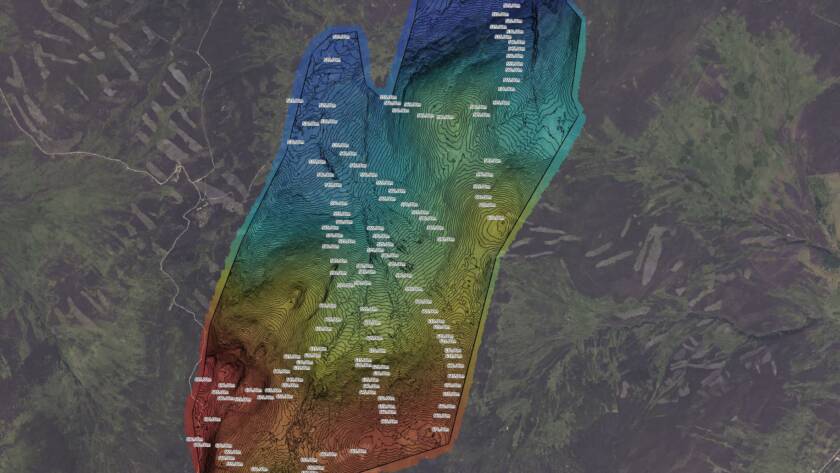
This guide details how to achieve high-accuracy drone mapping for construction using RTK/PPK drones, ground control points, photogrammetry, LiDAR, and compliant data delivery for precise, reliable site surveys.
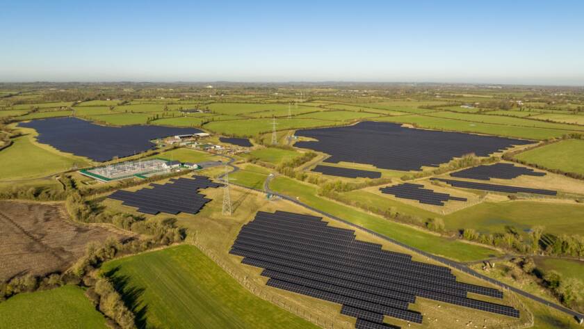
PB Aerial Imaging uses advanced drone technology across the UK and EU to enhance renewable energy asset management, improving inspection speed, safety, and efficiency while boosting energy yield.
Drone thermal imaging enhances renewable energy asset management by enabling early fault detection, improving safety, reducing downtime, and integrating data with maintenance systems for predictive, cost-effective operations.
Drone surveys revolutionize environmental impact assessments in challenging terrains by enhancing speed, safety, and data accuracy. PB Aerial Imaging uses advanced RTK/PPK, LiDAR, and multispectral tech for precise mapping across…
To provide the best experiences, we use technologies like cookies to store and/or access device information. Consenting to these technologies will allow us to process data such as browsing behavior or unique IDs on this site. Not consenting or withdrawing consent, may adversely affect certain features and functions.
Functional
Always active
The technical storage or access is strictly necessary for the legitimate purpose of enabling the use of a specific service explicitly requested by the subscriber or user, or for the sole purpose of carrying out the transmission of a communication over an electronic communications network.
Preferences
The technical storage or access is necessary for the legitimate purpose of storing preferences that are not requested by the subscriber or user.
Statistics
The technical storage or access that is used exclusively for statistical purposes.The technical storage or access that is used exclusively for anonymous statistical purposes. Without a subpoena, voluntary compliance on the part of your Internet Service Provider, or additional records from a third party, information stored or retrieved for this purpose alone cannot usually be used to identify you.
Marketing
The technical storage or access is required to create user profiles to send advertising, or to track the user on a website or across several websites for similar marketing purposes.