
Peatlands are one of the UK’s most precious natural carbon stores — but they’re also among the most fragile. Peatland Restoration is vital for biodiversity, climate change mitigation, and water management. Traditionally, mapping and monitoring these remote landscapes meant long days in boggy terrain, slow data collection, and sometimes limited coverage.
Now, drone mapping is changing everything for Peatland Restoration.
At PB Aerial Imaging, we use advanced UAV (uncrewed aerial vehicle) technology to capture the full picture quickly, safely, and with precision. Here’s why that matters for peatland restoration projects of every scale.
1. Precision Aerial Mapping for Accurate Peatland Planning
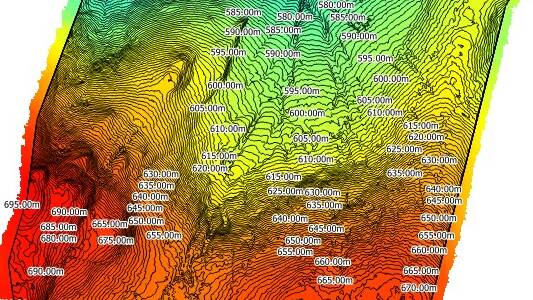
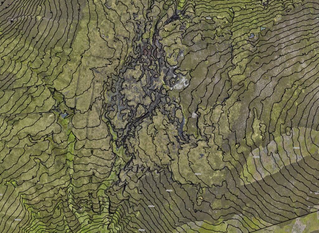
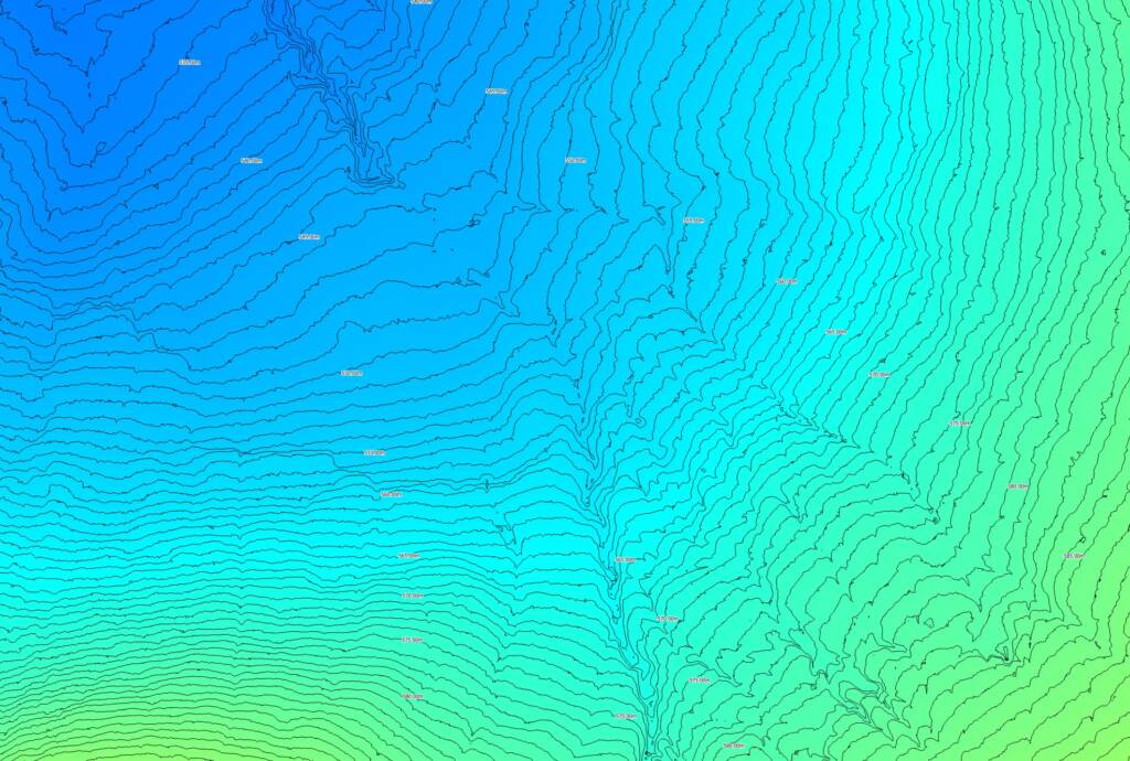
Effective peatland restoration starts with precise and reliable mapping. Before any restoration work begins, it’s essential to have an accurate picture of the land’s current condition. At PB Aerial Imaging, we use advanced drone technology to create high-resolution orthomosaic maps, Digital Surface Models (DSM), and Digital Terrain Models (DTM). These detailed outputs reveal exactly what’s happening on the ground — from grips and gullies to haggs, peat hags, and erosion scars.
Our UAVs (Unmanned Aerial Vehicles) are equipped with RTK-GPS positioning systems and advanced sensors, enabling survey-grade accuracy that meets the needs of ecological consultants, land managers, conservation organisations, and project planners. This level of precision supports smarter decision-making and better long-term outcomes.
For best practice guidance, you can explore NatureScot’s UA Deployment & Data Guidance, a recognised resource for using drones in peatland restoration projects.
2. Faster, Safer, and More Cost-Effective Surveys
Surveying peatland on foot can be slow, physically demanding, and potentially hazardous. Long treks across boggy ground not only take time but also risk disturbing sensitive habitats. Our drone surveys offer a fast, safe, and environmentally friendly alternative, covering vast and remote areas in a fraction of the time.
Compared to traditional ground-based survey methods, drone mapping:
- Reduces survey times from days to hours
- Lowers operational costs significantly
- Minimises environmental disturbance to delicate peatland ecosystems
- Keeps surveyors safe and dry, even in difficult weather conditions
- Captures consistent, repeatable data for reliable monitoring
By reducing human impact on fragile sites, UAV surveys help protect peatlands while delivering the insights needed for effective restoration.
3. Monitoring Peatland Restoration Progress Over Time
Peatland restoration is rarely a quick fix — it’s a long-term process that benefits from before-and-after cRestoring peatland is a long-term commitment that requires regular monitoring to measure progress and adapt strategies. Our aerial mapping services allow you to track changes year-on-year, creating a clear picture of ecological recovery.
With our time-series drone data, you can:
- Monitor vegetation regrowth and habitat changes
- Assess the success of drain blocking, reprofiling, and rewetting measures
- Detect early signs of erosion, drying, or water loss
- Measure volumetric changes in reprofiled slopes and restored areas
This visual, measurable evidence is ideal for reporting to funding bodies, stakeholders, and environmental regulators, ensuring transparency and accountability in your restoration project.
4. Sharing Results That Inspire Action and Engage with your audience
High-quality aerial imagery doesn’t just help with technical planning — it’s also a powerful storytelling tool. Whether you’re applying for grants, running public engagement events, or presenting findings to your team, our visuals make complex data easy to understand.
From breathtaking aerial still images of restored peatland to animated 3D terrain models, our mapping outputs allow you to share your success in a compelling and visually engaging way. These visuals can help build community support, secure funding, and inspire continued conservation efforts.
Your Peatland Project, From Above
We’ve worked in challenging upland environments throughout Scotland and understand the demands of working in remote locations with limited access. With CAA-approved pilots, full insurance, and over nine years of experience in specialist survey work, PB Aerial Imaging is your trusted partner for peatland restoration and aerial mapping projects throughout Scotland and the UK.
👉 Ready to map your peatland restoration site?
Contact us today for a free consultation and see how our drone mapping services can give your project the insight it deserves.
📧 Get in touch or call us directly on +44(0) 7730600943
#peatlandrestoration #aerialsurveys #dronesurvey
