

Advanced Drone Thermography for Renewables and Wildlife Management: Turning Heat into Insight
Most renewable energy inspections still rely on slow, manual methods that miss critical faults until they escalate. You need thermal imaging drones Scotland trusts to deliver rapid, precise data for wind turbines, solar farms, and wildlife habitats. PB Aerial Imaging’s advanced drone thermography UK service captures radiometric thermal mapping and GIS-ready thermal data, giving you clear insights that drive timely decisions and protect your assets. Learn more about technology innovation in this field here.
Advanced Drone Thermography Techniques

In today’s world, precision is key, especially when it comes to maintaining renewable energy assets and managing wildlife habitats. Discover how advanced drone thermography techniques deliver the accuracy you need.
High-Precision Thermal Imaging
Imagine seeing invisible faults before they cause damage. That’s what high-precision thermal imaging offers you. This technology detects temperature differences with incredible accuracy. For example, a solar farm manager spotted a 15% drop in efficiency due to a single faulty panel. By using thermal imaging, they identified and replaced the panel promptly, restoring optimal performance. This capability is not just about fixing issues; it extends the lifespan of your assets.
Mission Planning for Optimal Data
Collecting accurate data requires more than just flying a drone. Proper mission planning ensures you get the right data every time. By understanding terrain, weather, and asset layout, you can maximise your inspection’s effectiveness. Imagine planning a mission where the drone flies at a specific angle to capture the entire surface of a wind turbine. This level of detail is crucial for early fault detection. Don’t leave your data to chance—plan for success.
Ensuring Safety and Compliance
Safety can’t be compromised. With drones, you maintain a safe distance from hazardous areas while still getting the data you need. Compliance is equally important. Being a CAA approved drone operator ensures our processes meet legal standards, giving you peace of mind. In the high-stakes world of renewable energy, safety and compliance are non-negotiable.
Applications in Renewable Energy
From solar farms to offshore wind turbines, renewable energy relies on efficient operation. Let’s explore how drones make this possible across different applications.
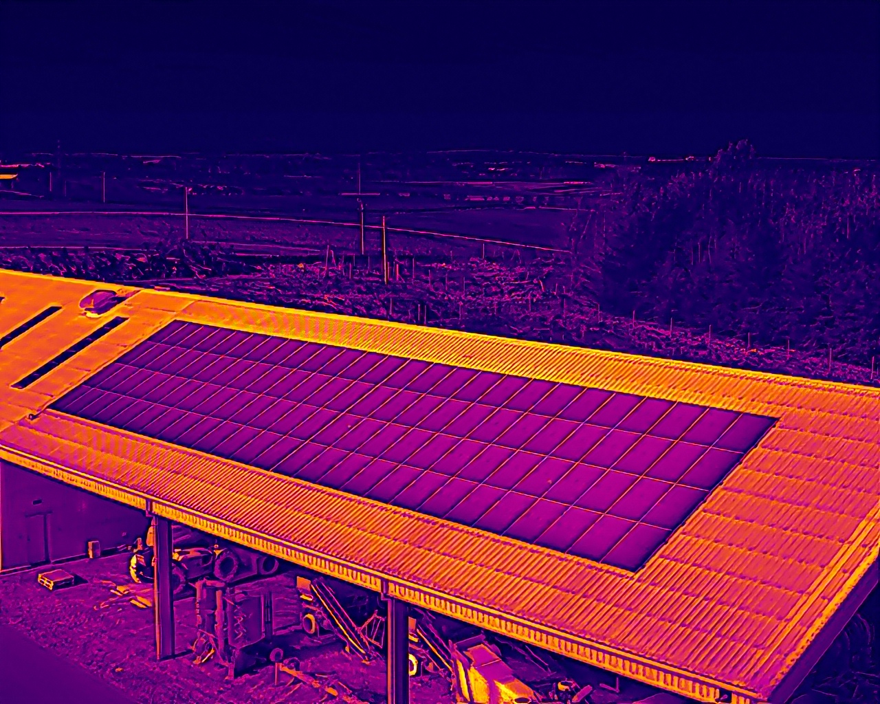
Solar Farm Thermal Surveys
Solar farms are vast and complex. One faulty panel can cause significant energy losses. With thermal imaging drones, you can conduct a solar farm thermal survey efficiently. These drones detect PV hotspots and perform IEC 62446-3 PV inspections, ensuring each panel functions correctly. In one case, a solar farm reduced downtime by 20% after identifying malfunctioning panels through drone surveys. This proactive approach saves time and maximises energy output.
Offshore Wind Turbine Inspections
Offshore wind turbines face harsh conditions. Regular inspections are crucial to maintain performance. Drones provide a safe and efficient way to inspect these structures. By using drones, you can spot issues like blade erosion or overheating components early. This proactive maintenance reduces the risk of costly repairs. Offshore wind turbine inspection with drones ensures your turbines operate efficiently and safely.
Substation and Cable Joint Thermography
Substations and cable joints are critical to energy distribution. Even minor faults can cause major disruptions. Drone thermography identifies heat anomalies that signal potential issues. This means you can address problems before they escalate, ensuring continuous power supply. With drones, you achieve precise, reliable inspections that keep your energy systems running smoothly.
Wildlife Management and Conservation
Beyond energy, drones play a vital role in wildlife management. They provide insights that are crucial for conservation efforts. Here’s how.
Systematic Wildlife Thermal Surveys
Understanding wildlife populations is key to effective management. Traditional methods can be disruptive and imprecise. Enter drones. By conducting systematic wildlife thermal surveys, you gather accurate data without disturbing animals. This approach is invaluable during nocturnal hours when wildlife is most active. Discover more about safeguarding wildlife with thermal imagers here.
Ground-Nesting Bird Detection
Ground-nesting birds are vulnerable to human activity. Protecting them requires precise monitoring. Drones equipped with thermal imaging can detect these nests without causing disturbance. This technology aids conservationists in safeguarding bird populations effectively. It’s a game-changer for sensitive habitats where traditional monitoring methods fall short.
Peatland Restoration and Monitoring
Peatlands are vital for carbon storage and biodiversity. Monitoring their health is essential. Drones offer a non-invasive way to survey these areas. By capturing GIS-ready thermal data, you gain insights into moisture levels and vegetation health. This data supports restoration efforts, ensuring peatlands continue to thrive. For more on this topic, check out this study.
By leveraging advanced drone thermography techniques, PB Aerial Imaging empowers you to make informed decisions, preserving both your assets and the environment. Whether it’s renewable energy inspections or wildlife management, our drones provide the insights you need to excel.
