AI-powered drone inspections by PB Aerial Imaging enhance predictive maintenance for energy assets across UK/EU, offering precise, safe, and efficient monitoring of wind, solar, and oil & gas sites.
Drone-based Environmental Impact Assessments enhance accuracy, safety, and efficiency with high-resolution data, hazardous area access, rapid analysis, and GIS-ready outputs, revolutionizing environmental surveys and monitoring.
This guide details UK CAA and EASA drone regulations, safety protocols, RAMS, certified pilots, and advanced techniques like EVLOS and RTK for compliant, precise offshore drone inspections in wind, oil,…
Advanced drone mapping and thermal imaging enhance construction and renewable energy projects by providing precise RTK surveys, progress monitoring, cut/fill analysis, solar thermography, turbine inspections, offshore asset checks, and detailed…
This guide details UK CAA and EASA drone regulations, certifications (GVC, A2 CofC), risk assessments (SORA, RAMS), GDPR compliance, and offshore drone applications in energy and industry.
Drone mapping and thermal imaging enhance construction and renewable energy projects by providing precise, cost-effective surveys, real-time monitoring, BIM-ready models, and efficient inspections, improving accuracy, safety, and timelines.
This guide details offshore drone operations from planning to delivery, emphasizing safety, compliance, advanced technology, precise inspections, and high-quality data for wind turbine and oil platform maintenance.
Advanced drone surveys in the UK enhance asset inspections by improving safety, cutting costs by up to 50%, and boosting efficiency, transforming renewable energy and construction site monitoring.
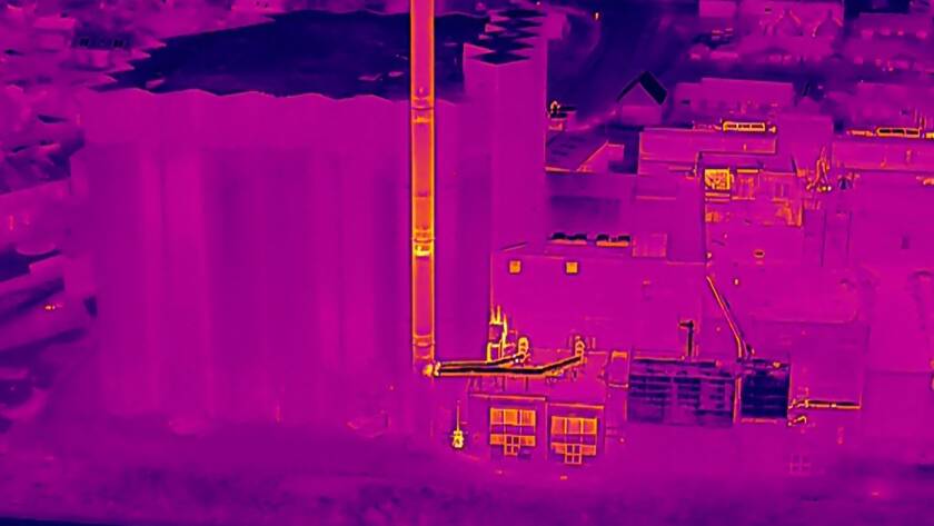
Unlocking Uptime: Drone Thermal Imaging for Renewable Energy Asset Inspections You spend hours managing renewable energy assets only to face unexpected downtime that drains your budget and delays projects. Drone…
To provide the best experiences, we use technologies like cookies to store and/or access device information. Consenting to these technologies will allow us to process data such as browsing behavior or unique IDs on this site. Not consenting or withdrawing consent, may adversely affect certain features and functions.
Functional
Always active
The technical storage or access is strictly necessary for the legitimate purpose of enabling the use of a specific service explicitly requested by the subscriber or user, or for the sole purpose of carrying out the transmission of a communication over an electronic communications network.
Preferences
The technical storage or access is necessary for the legitimate purpose of storing preferences that are not requested by the subscriber or user.
Statistics
The technical storage or access that is used exclusively for statistical purposes.The technical storage or access that is used exclusively for anonymous statistical purposes. Without a subpoena, voluntary compliance on the part of your Internet Service Provider, or additional records from a third party, information stored or retrieved for this purpose alone cannot usually be used to identify you.
Marketing
The technical storage or access is required to create user profiles to send advertising, or to track the user on a website or across several websites for similar marketing purposes.